Category: Pacific Crest Trail

  • Day 139 – Banner Peak

    Day 139 – Banner Peak

    At mile 936. Hiked 23.8 miles today.

    I met a pair of thru-hikers heading southbound. Their trail names were David and Z. David’s real name is Mike. Nobody seemed to be able to remember his real name so they named him David since it was presumably easier to remember. Z got her name because she hikes with Chacos, leaving Z tan marks on each foot.

    David and Z and I had never previously met, but we knew all the same PCT hikers. It was fun talking to them to catch up on all of our in-common friends. They had hiked with Ridge Route and Shortcut in Washington. I told them that RR and Shortcut were in the Sierras now. Z had met Cache 22 at the Oregon border where they were both starting their hikes. There were many others that we both knew or met such as Bear, Flying Amaneta, Hummingbird, Rifle, etc.

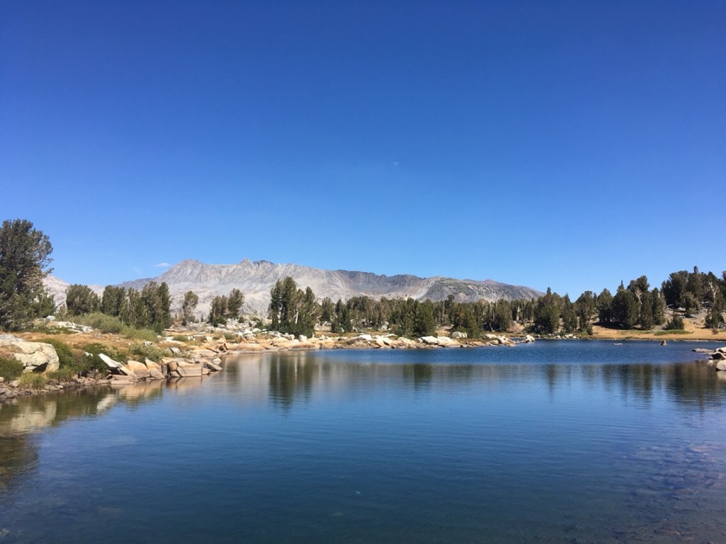
    Here is a small lake where I ate lunch, soaked my feet, and napped.

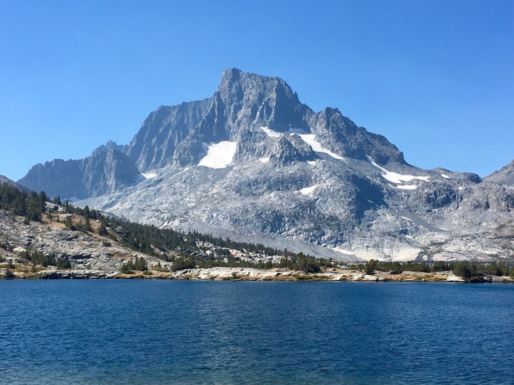
    Banner Peak in Ansel Adams Wilderness.

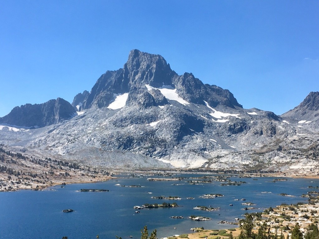
    Banner Peak with Thousand Islands Lake.

    The trail. (more…)

  • Day 138 – Double Cheeseburger

    Day 138 – Double Cheeseburger

    At mile 912.2. Hiked 16.2 miles today.

    Today I had an easy trail the entire day. The trail surface was smooth and the slope was gentle. After 10 miles I arrived at Reds Meadow.  I went directly to the General Store to buy a beer, then to the cafe to order a double cheeseburger to go with my Sierra Pale Ale. 

    Needing only one breakfast and one dinner, I resupplied from the hiker box. I just finished eating a mystery chicken and rice dinner that I had chosen from the hiker box. It turned out to be great. You are never too sure what you are getting when it isn’t in the original packaging. 

    Other hikers were opening their resupply packages and offering me food they did not want to carry. I had to refuse most offers or I would have been carrying too much. 

    After eating, resupplying, updating blog posts, and charging my external battery, I hit the trail again. With 36 miles to my next resupply at the Yosemite Tuolomene post office, I wanted to cover a few miles as insurance that I would arrive on Saturday before the 1:00 pm post office closing time. Tonight, I am camped on the bank high above the San Joaquin River.

  • Day 137 – Silver Pass

    Day 137 – Silver Pass

    At mile 896. Hiked 17.3 miles today plus 1.5 miles to return to PCT via Edison Ferry trail.

    Everyone exiting the Edison Ferry after a good time at VVR. Now, Hike!

    The trail toward Silver Pass. A lot of vertical from VVR.

    Clouds, but no rain.

    View from Silver Pass.

    I think that might be Ritter Peak in Ansel Adams Wilderness.

    Lake and clouds. Virginia Lake. I don’t want a weather repeat. My down vest is stuffed in my dry sack this time.

    My campsite for the night. Big day tomorrow at Reds Meadow. I’m planning a hot meal, resupply, and hike out toward Yosemite.


  • Day 136 – Hail Storm

    Day 136 – Hail Storm

    At mile 878.7. Hiked 21 PCT miles plus 1.5 miles back to PCT from Muir Trail Ranch (MTR) plus 1.5 miles from PCT to Edison Boat Ferry for Vermillon Valley Ranch (VVR).

    As I departed at 6:20 am, I took this photo of just a few of the later risers tenting at MTR.

    One of several lakes leading up to Selden Pass.

    Another lake. I met a large group from South Korea here. One of them had hiked the SO-CAL portion of the PCT last year. 

    Another view of the same lake.

    The first lake north of Selden Pass was Marie Lake.

    Another view of Marie Lake. Notice the tiny clouds and how they build across the photos.

    Here is the rock I swam from in Marie Lake at 10 am.

    My shoes and socks laid out as I swam in Marie Lake.

    Another view from Marie Lake. The once almost imperceptible clouds had already grown significantly during the short period I was at Marie Lake.

    The trail and Marie Lake.

    Onward. Further down the trail.

    Another view before I stopped for lunch.

    Decision made to go to Vermillion Valley Resort

    I ate a leisurely lunch alongside a stream. When I finished I checked my app for distances and saw that the turnoff toward VVR was 9.8 miles away, then another 1.5 miles on a side trail to the ferry. It was 12:45. The ferry leaves at 4:45 pm. Four hours. I could make it if I averaged my typical 3 mph. If not, no problem. I didn’t need a resupply and I would be that much closer to my next stop. I would only go for the hot meal and to see what VVR was like.

    Drenched in a Hail Storm

    As I started climbing Bear Ridge, the rain started soon turning to rain and hail. The turn in weather spurs me to hike faster and I destroy one switchback after another. Before I topped out, the temperature had plummeted and I was soaked. Hail was falling thickly. Soon there were little rivers of water running down the trail. I began a long steep descent along the freshly washed-out trail. I noticed that distant mountain slopes in every direction were coated white with hail.  I was getting colder, so cold in fact, that I began praying for any flat spot where I could set up my tent, pull off my soaked clothes, and crawl into my dry sleeping bag.  After some trouble digging under the Tyvek that I had wrapped around my waist, I managed to fish an energy Pro Meal bar out of my back pocket. I wolfed down the whole bar and the shot of calories soon made me feel slightly warmer. To warm up bare hands, I walked with hands in my pockets, poles under my arm. This meant having no poles to help guide me down the steep rocky washed out trail. First one knee became sore, then both. I switched to using poles in a single hand, keeping my other hand in a pocket.

    Catching the Ferry in the Nick of Time

    I finally reached the trail junction to Edison Ferry. I actually ran some of the better parts of this side trail. Almost hypothermic, there was no way I was going to miss this ferry with the hot showers and warm food that it promised. The Edison trail was in horrible shape. I reached the lake, but I saw no ferry. I climbed a rock outcropping and spied the ferry moored about a quarter-mile further down the shore. It was already loaded with hikers. With no trail, I ran through the lake bed, climbing over rock and splashing through the lake with my Tyvek skirt blowing in the wind. This must have been some top-notch entertainment for those resting comfortably in the boat. I was the last person to board and we were soon off to VVR.

    Hot Food and Refuge at Vermillion Valley Resort

    Upon arriving at VVR, my first business was to wolf down a rib plate at the restaurant. Nothing ever tasted so good. Still hungry, I raided the hiker box, finding a couple of energy bars and a box of chocolates. I ate the chocolates first. Soon afterward, I bought a quart of chocolate milk and drank it dry. Now back at my tent, I’m eating dried apples from MTR (Muir Trail Ranch). I’m in my sleeping bag now and I am still hungry. It feels as though I didn’t eat. I thought about ordering a 2nd plate of ribs, but they were out. Oh, they were so good! With mashed potatoes and wonderful gravy. There was cauliflower that you couldn’t taste because it was so draped under a thick curtain of cheese. I’m already thinking about a hot breakfast at the restaurant as early as possible tomorrow morning.

  • Day 135 – Muir Trail Ranch

    Day 135 – Muir Trail Ranch

    At mile 857.7. Hiked 18.9 miles today plus 1.5 miles to Muir Ranch.

    At Muir Trail Ranch there were 5-gallon buckets labeled with categories for each type of food and other non-food items. Amazed at the abundance and variety of free food and supplies, I went down the line selecting the food I needed. I grabbed several Mountain House scrambled egg dinners. It was pleasing to think that I would have a break from the daily morning oatmeal over the next several days. I provisioned with enough food to get me to Reds Meadow. All compliments of John Muir Trail hikers that either overpacked or never made it this far. 

    After resupply, I walked to the camping area for hikers situated alongside the San Joaquin River. A rope is suspended across the river. I held onto the rope and pushed into the current, crossing the river to the hot springs. I bypassed the first small spring. A camper had warned me that he had encountered a large snake resting on a rock at the edge of the spring. Also, upon reaching the hot spring, I spied a naked man sprawled and floating in the hot waters. The spring was obviously too small to comfortably share with a naked man. Instead, I dangled my legs in the second spring, then crossed back over the river to my campsite.

    Early morning lake views high up on the north side of Muir Pass.

    Midmorning sun on a mountain.

    Marsh on way toward Selden Pass.

    Waterfall.

  • Day 134 – Muir Hut

    Day 134 – Muir Hut

    At mile 838.8. Hiked 23.2 miles today.

    Today I climbed both Mather Pass and Muir Pass. The valley that the PCT follows up to Muir Pass is my favorite spot on the PCT. The Middle Fork Kings River spills through this valley and there are quiet groves of trees at each level of the valley. The valley finally ends at a series of high mountain lakes. 

    While taking a dinner break on the Mather Pass climb, I met several young girls with day packs. They said that they were on a day hike. I asked whether they had a base camp nearby. They answered no and explained that they were hiking 55 miles today. They were doing a loop out of Bishop. It was already past 5 pm and I knew that the trail over Bishop Pass was 13 miles and they had about 6 miles left to reach that trail. I guess if they got into trouble on the JMT (John Muir Trail), they could get help from one of the few hundred JMT hikers that would be sure to be close at hand. 

    Here I am on top of Mather Pass in the early morning.

    View from top of Mather Pass looking south. I camped somewhere down there.

    Another beautiful lake.

    The trail makes its way down valleys like this one.

    Here is where I stopped for lunch. Just beginning the uphill toward Muir Pass. Soaked my feet in the cold water. It is first hard to walk on numb feet after a cold stream soak, but after a while, it feels good. I also soaked my shirt in the stream and put it back on. Cooling the body down makes it easier to hike.

    The lower valley leading to Muir Pass has beautiful marshes and meadows. 

    The valley has a stream that spills through many cascades.

    The valley has peaceful wooded areas interspersed with meadow.

    Looking back down the valley you can see areas dense with old trees.

    I took a break on the side of this cold stream. Again, I soaked my shirt.

    Another view from the stream.

    Higher mountain lakes. I enter the alpine. Muir has a long snowfield approach in the early summer. Good thing I am not here in early June.

    Muir Hut.

    Muir Hut and my tent in the lower right corner of the photo.