Category: Pacific Crest Trail

  • Day 37 – One Man Band

    Day 37 – One Man Band

    Flipped to Walker Pass and hiking south toward Hikertown. Hiked 23.9
    PCT miles. At mile 517. 6.

    One Man Band was walking north along the LA aqueduct with a guitar strapped to his pack when I stopped to chat with him. Everyone who thru-hikes carries a part of themselves with them. For One Man Band, it is the love of music and the way that music opens people up to self expression. One Man Band told me that he found PCT hikers particularly expressive. I’ve seen this myself with the art created at hiker hangouts like Casa de Luna and in a number of PCT 2018 signature banners. One Man Band also carries drumsticks, a small kettle drum (forgot to ask whether this doubles as a cooking pot), and a harmonica. At Hikertown he brought out his instruments and played the Hikertown piano as other hikers joined in with an improv session. Here is the Hikertown piano at the lounging area and kitchen.

    I have completed 134.4 mile flip from Walker Pass SOBO to Hikertown. This completes the first section of my PCT hike from the Mexican Border at Campo to Walker Pass, placing me at mile 652.1. I will take a few weeks to return to Atlanta to see my wife, Sandra, for the birth of my first grandchild and my daughter, Maura’s college graduation.

    I wasn’t cold sleeping in Tylerhorse Canyon. The tarp anchored by tent stakes held down by massive rocks stayed secure through winds that otherwise caused the tarp to violently flap so much that it would push against my body and whack me in the face. At times the wind would completely stop. The gibbous waning near full moon rose. Night clouds drifted, then rested, highlighted in backlight effect by the moon. The bitter cold wind in morning meant that the tarp, the only refuge from bitter wind would be last thing I packed.

    As I pulled on the quick laces of my left boot, the already frayed string snapped. These Salomon X-Ultra boots use Salomon Quick laces so I knew no way to repair and replace. 

    I walked with a loose left boot. By the end of a 24 mile day a blister was springing up on the front pad my of my foot. 

    Here is the view looking back to cloud banks toward the mountains.

    Here are more clouds.

    Here is the Joshua tree that I took a longboard lunch break under.


    Here are Hikertown tiny accommodations.

    I pitched the tarp in the dark at Hikertown, right next to what turned out in the morning to be a pigpen.

    Here is the pigpen.

    PCT shorts:

    Walking in dark along aqueduct levy, listening to Dark Side if the Moon.

    While night hiking seeing what comes out of those 2 – 3 inch diameter holes. Catching a large mouse frozen in the headlamp.

    Many NOBO’s were so intent on hiking that they didn’t think to ask me, a SOBO, about trail info and water availability. Some few don’t even respond to a greeting. I was likely the only SOBO most saw in more than a few days. This makes me appreciate the need not to miss similar opportunities myself.

  • Day 36 – Better weather, for me at least

    Day 36 – Better weather, for me at least

    Flipped to Walker Pass and hiking south toward Hikertown. Hiked 16.7
    PCT miles. At mile 541.5.

    The weather was on my mind. I didn’t want another windy day. The wind wasn’t as strong and as clouds gathered the wind seemed to stop at times. As I continued to climb toward the clouds, I became a little worried about rain. I never reached the clouds, but at the highest elevation for the day a few snowflakes fell for a short while. As I lay here under the tarpon Tylerhorse canyon, the wind is kicking up and clouds are threatening. Even though I am in the desert with its reputation for heat, it has been cold so far, though I’d rather be in the desert than in the higher mountains. The mountains are blanketed by clouds and I heard that snow was expected higher up. I’m so lucky to have flipped this portion of the hike so that I am in the desert when the really rough weather rolled in.

    Upon arriving at Tylerhorse Canyon, I walked up and sown the canyon looking for the easiest spot to draw water from the meager trickle. I noticed motorcycle tracks in the stream bed and recalled that earlier in the day that hikers had told me that they saw a guy riding his motorcycle up and down the stream. They asked him to stop and he ignored them and continued his destruction of this fragile stream. This water source is the first natural water source out of the Mojave desert. As it is, it dries up each year. Many hundreds PCT hikers use it each hiking season.

    I saw Wallet, the guy that borrowed the trail angel’s car in Wrightwood. The trail angel told him to leave it parked in the driveway when he was finished. Wallet told me that he returned the car, but another hiker decided to use the car and the Trail Angel thought Wallet hadn’t returned the car. After several hours they figured out that another hiker had taken it and found the car.

    I continued to pass Northbound hikers that I know. I was particularly happy to see the Green Lantern. Also saw Google. Saw the Aussies and Brits, but their numbers seem diminished. They had just hiked off trail to retrieve water. One guy had collected 6 liters. I broke the news to them that their was a large water cache sitting for them at the end of a 3.5 mile climb. Oh well, at least they know so they can pour out most of that water rather than lugging it up a 1600 vertical foot climb.

    Some photos from the near highest elevation for the day. The last real tree before much dryer desert.

    Here is what it looked like after I started descending toward the real desert.

    Here are the trail switchbacks along a canyon.

    Flowers

    This is the first time I’ve seen one of these trees bloom. Still don’t know the name.

  • Day 35 – Boy Scouts serving others

    Day 35 – Boy Scouts serving others

    Flipped to Walker Pass and hiking south toward Hikertown. Hiked 8.2
    PCT miles. At mile 558.2.

    I stayed in the Santa Fe motel last night. Hot shower and room to organize my resupply. A plus is that it is across the street from Kohnen’s Country Bakery, a popular hiker spot for delicious pastries and coffee. I had a roll with eggs and sausage cooked inside and an almond danish.

    Witt’s End is a place where Dalton, who happens to be from my hometown, Atlanta, runs a place for hikers to hangout, rest, and find rides and services. Here is the PCT 2018 banner that I signed.

    Here is my signature with the original version of my blog logo. 

    Dalton located trail angels, Melissa and Old Spice to drive me back to the trail. Both had become new people, Melissa when she recovered use of her hands follows stroke, Old Spice when he became Old Spice and left Fox News addict, Jim, behind. Melissa gave me these 2 peace sign pennies that she made with her new hands. Thank you for the ride and the great story of inspiration. Anyone can change, Never believe it isn’t possible.

    Here is the bridge over Hwy 58 that the PCT crosses. The view is toward Tehachapi.

    Here Is where the PCT crosses the double railroad track. The 2nd set of rails were built at great trouble because this was the route from California Central Valley to Las Vegas and points East. Many. Men lost their lives working on the 13 tunnels needed to get the tracks laid over Tehachapi pass. Maybe the Netflix series, Hell On Wheels, makes railroad building seem a little too easy. 😉

    Here is the view of the zig-zag uphill ascent, looking down from above. There is nearly always a climb after every town and why not? After all, “Everything is Better Uphill”.

    Here is a bench at the top of the hill. This was part of an Eagle Scout project. Time and again I see the contributions and involvement of Scouting with the PCT.

    Wind mills. There were hundreda upon hundreds in all directions. There was a lot of wind also. Everyone has had enough of the wind. This is the last photo of a windmill I will post unless a windmill gets in the way of a bear photo.

    Skies and mountains.

    A painted rock left on the aise of the trail wishes hikers well.

    My campsite is in a ravine, the one spot out of the wind.

  • Day 34 – Living on Peanut Butter and a Prayer

    Day 34 – Living on Peanut Butter and a Prayer

    Flipped to Walker Pass and hiking south toward Hikertown. Hiked 16.9
    PCT miles. At mile 566.4.

    Today was to be my day of rest. I would sleep late, take a long breakfast, and leisurely break camp before hiking a few miles to a tent site that would leave me a couple hours hike the next morning for a meet up with cousin Margaret with resupply, trail magic, and town food.

    The weather didn’t agree with these plans. It was cold and windy and although I stayed in the sleeping bag longer than usual, the biting wind urged me to quit this place and get moving. As I hiked, I tried to slow down by taking an abundance of breaks and I succeeded at first.

    I also had to use extreme measures to conserve my phone battery. The previous night I had discovered that my external battery pack was dead with my phone battery in the low teens. I hiked with the phone powered down; meaning fewer photos no Guthook for reassurance that I had not strayed from the trail. I concentrated on looking for the few PCT logo trail markers. I followed a dirt road MK10 for what turned out to be 4.4 miles, always looking for boot prints in case the trail turned off road. Areas where trails intersect and follow dirt roads are the easiest places to miss a turn. I think I may have mentioned U-Turn, a young Belgian, who did just that, finding himself 4 miles off trail before he made a U-turn to retrace his steps. I wonder how challenging it was to hike the PCT before GPS devices. There was few other hikers with which to share information and few water caches. Since few people had ever heard of the PCT, trail magic was really magic because it mostly didn’t exist and seemed to appear out of thin air.

    After the long walk on MK10 ( I don’t like walking these deeply rutted uneven rubbly steep 4WD roads that make it easy to lose your footing.) the trail hit open ridge line. Clouds were sweeping over and the wind increased. The wind was stronger than the day I hiked into Wrightwood. A little bird by the trail was hopping up a foot or two, launching itself against the wind. I was thinking how it could do that without being blown away. Each time it struggled a few seconds, then dropped to the ground in the same place. On the fourth try the bird hopped up and was suddenly blown off the mountain, completely out of site. It was a strange thing.

    For long distances it was an absolute struggle to walk. This was not playing around.

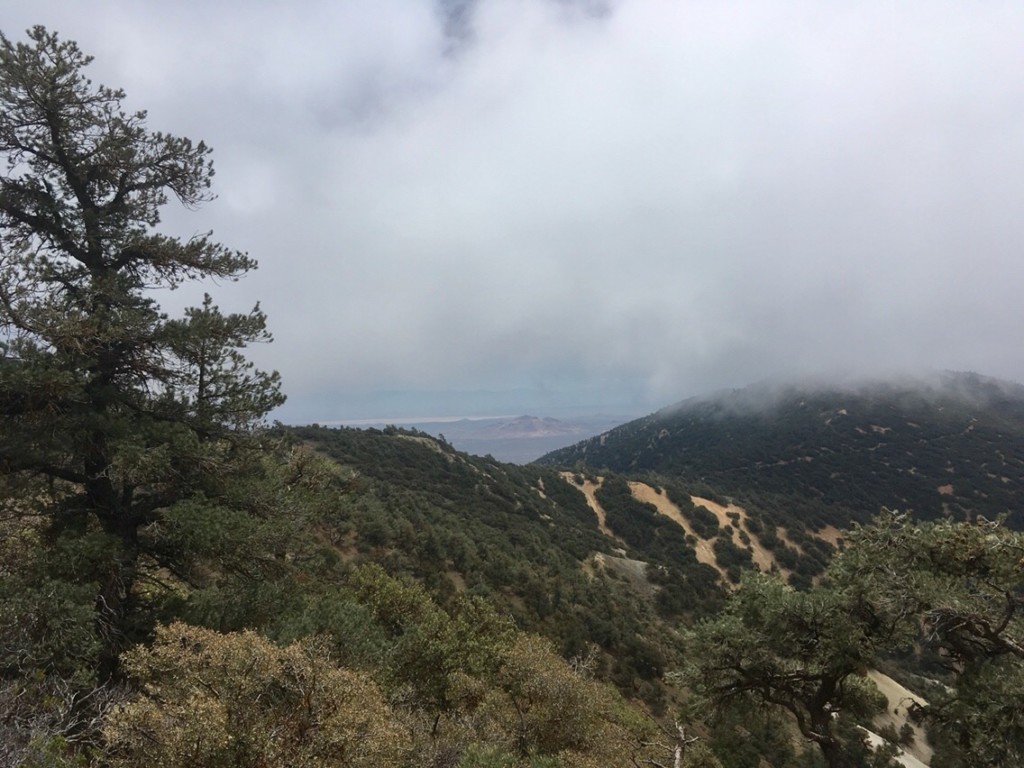
    Photo below looks innocent enough, but wind is harder to photograph than snow. The trail curves around point on far left. The steep slope is what worried me.


    I tightened up backpack straps and belt for better center of gravity. I choked up on my hiking poles, lowered my stance with knees bent. Picture a Sumo wrestler who is fighting to be kept from being pushed out of the ring. Even with this stance, I was pushed around and off the trail. My knees became a little sore with the struggle. The relatively flat open meadows were one thing, but where the trail crossed steep terrain it was another matter. I concentrated harder than ever to stay on the narrow 3 foot wide path to keep from being pushed off steep slopes. After what must have been mile or two of the worst piece, I dropped to areas that seemed a little less intense. At that point I was surprised to see a couple of backpackers struggling in the wind as they made their way up to me. I didn’t expect to see anyone attempting this ascent in these conditions this late in the day. It would be miles of climbing and high winds before reaching any reasonable camping spot. Only a few hours before, a NOBO was pleading for info on any camping sites up ahead that were out of the wind. Reaching the pair, I was surprised to find underneath all that wind gear none other than Michael and the Professor! These two determined German men are in their late 50’s or 60’s. Although I hike faster and carry a lighter pack, they seem to persevere and catch up through what must be sheer willpower. I have seen their suffering. Others would take a zero day or at least a shorter day. We exchanged greetings. Michael doesn’t speak English so the professor does the talking. We passed and the pair proceeded upward into ever fiercer winds as I soon dropped into relative calm. As I walked on, I thought of Michael’s tiny pup tent. It always stood out among the better and bigger tents because it looked like a tent that you expected a kid to use for a backyard camp out. How would that tent, or any tent for that matter, hold up in that wind. I worried about Michael and the Professor.

    (more…)

  • Day 33 – Rain?

    Day 33 – Rain?

    Flipped to Walker Pass and hiking south toward Hikertown. Hiked 21.1
    PCT miles. At mile 583.3.

    There was strange weather today. Coyboy camping again, I awoke early seing stars through the tall pines, but no stars in the western sky. After hiking a mile or so I crested a minor ridge and I saw a blanket of clouds on mountains below with some other clouds skirting the hill just ahead.

    Weather was normal when I saw this long lived oak tree in the early morning.

    A little more hiking and I was in this weather. The clouds swept through and the trees gathered and dropped the moisture. For the next 6 hours, I was walking through clouds and tree rain. The pines seem particularly adept at sweeping up cloud moisture. In places water began to run down the trail. I wore my rain jacket and fleece pants and allowed my hands to become near numb before a complete pack search for my gloves. The gloves were in the food bag, not their normal place. When I eventually found them, I recalled having placing them there to keep them dry. When my hands warmed I was once again able to use them in snaps, buckles, and zippers.

    I finally crossed another ridge where there was a weather tower and a little blue sky. The wind increased as the skies cleared. It stayed cool all day long. Soon I thought I saw an apparition through the mists and realized that there were windmills rotating nearby. I. Left the clouds behind and entered the land of blue sky and wind. With clear skies, miles of windmills.appeared. Other hikers, all northbound, hardly believed it when I reported that I had been hiking through rain all day and that could expect the same. It is clear to me now how the Mojave is so dry. These mountains soak up and wring out all of the clouds before the can reach the Mojave.

    Here I looked back toward the distant cloud that covered rainy mountains I had earlier hiked.

    Here I look back from an even greater distance.


    The last several days I had wondered which NOBO (northbound) hiker that I knew would be the first that I would meet on my flip hike to the south. This person would be a worthy hiker who had either managed to pass me and/or stay ahead of all the other hikers that I met along the way. Near the end of the day II met this worthy hiker. It was Lady, an AT thru-hiking they-hiking veteran., who had accomplished this feat even after taking a double zero. Congratulations Lady! I’d give you a patch or something if I had an actual award for this. Before the end of the day I saw previous trail meets Baby Lungs, who was at Hikertown when cousin Margaret bestowed cornucopia of trail magic. He had since met Lady.

    Here are the trail flowers of the day which were found near the end of the day not far from some windmills.

  • Day 32 – No Pain

    Day 32 – No Pain

    Flipped to Walker Pass and hiking south toward Hikertown. Hiked 23.9
    PCT miles. At mile 604.4.

    Today I felt much better. I had an early start shortly before sunrise. I took a couple of Ibuprofen with the idea it could help prevent left shoulder pain. I was also made comfortable with the thought that thanks to my stomach my pack weight was decreasing. I took care to do a series of shoulder stretches as I hiked and believe it or not, this was the first day in weeks that I was free of shoulder pain.

    Here is a mountain that appears to have stains of yellow. Those are actually thousands of yellow flowers.


    Here is a snake.

    Here is another snake.

    Here is a rattlesnake. That makes 3 snakes today, 4 Rattlesnakes so far, and 12 snakes in all on this hike. I thought I had good video of the rattler, but I was not recording, AGAIN! The second time I messed up trying to video a rattlesnake.

    Here is a photo from the top of a long climb. I felt like I had to show I did it. After all, it was so much work. Overall, the trail was easy and I had a great deal of level and descent.

    Hiking south, I should eventually see people I know that are headed north. Not yet, though, I am seeing a lot of people heading north for their reckoning with an early entry in the snowy cold Sierras. A few of these people will be there before the end of April. The last couple of days have turned cooler. How cold would that be in the Sierras at over 10,000 feet.

    Here are some trees I love They turn and twist and branch out. I need to find out the name for these trees. If you know these trees, post a comment.

    I had thought that the rest of the way to Hikertown wouldn’t involve large trees. I’m actually camping in trees tonight. Here is a photo of tall pines.

    Here are flowers along the trail. I can’t express the variety and mixes of flowers. There are violet, white, blue, red, and multiple shades of yellow. There are tiny flowers that accent the arrangement of larger flowers and everything is set in a landscape of stones, boulders, and rock outcroppings. It is better experienced, than photographed.