
16 Feb Yosemite North
There were more bear and bear cubs than I bargained for during a week hiking thru Yosemite Wilderness North Country in September. On the 2nd day, I had the panic of running up on a couple of bear cubs and wondering whether I might be between an unseen mother bear and her cubs. On the final day, I was resting on the trail side when a mother bear and cub passed within feet of me totally unaware of my presence. Read on for more on these and my other experiences on this hike.
A 2 minute video tracing my route on a Yosemite trail map.
To view this on a full screen, click the Youtube icon on the lower right corner in order to view the video on Youtube’s website.
Next, click the full screen icon that you will again find in the lower right corner of the view screen.
This will open a new tab or window so in order to continue reading this blog, you will need to switch back to this tabbed window.
Preparation
September 21, 2012
This is my third hiking trip through the Yosemite Wilderness and the earliest in the year. In 2009 and 2010 I hiked through snow. This time instead of mid to late October, I chose late September and found out just how hot and dry it could be in the high country.
I drove my rental car from Sacramento to the Merced Airport where I turned it in and caught the YARTS shuttle. (I was only the 2nd pick up all season long from the airport for this YARTS shuttle driver.) He was friendly and was celebrating his last run (ever) to Yosemite Valley.
As we pulled into the valley in the deep dark, he pointed out a several tiny pinpoint lights along the distant darkened wall of El Capitan. There were four or five interspersed lights in the form of a line leading straight up the wall. There was an another light off to the side and about half way up. I guess that was a climber with an independent spirit.
I exited the shuttle at Curry Village. I had been reading about the Hanta Virus infections and deaths at Curry Village. Plenty of friends had also helpfully warned me to avoid Curry Village and its tent cabins. It was pitch black, and with my duffle bag and backpack I excitedly began the trek to the backpackers campground. I had remembered the the campground being on the backside of a “pines” something or other campground just to the left on the opposite side of a stone bridge that spanned the Merced river. I passed South Pines, then Mid-Pines. It had seemed that I had come a long way and in the dark the entrance to Mid-Pines Campground looked familiar. The river was to my right and I hadn’t crossed the stone bridge. At the far back side of Mid-Pines, I realized that I should have turned left at the next campground. Instead of backtracking, I walked the the stream and climbed up the opposite bank to the backside of North Pines Campground. I wandered through a family’s campsie and explained what I was doing. It wasn’t long before I found the right path, crossed the footbridge and entered the crowded backpacker campground. In October 2010 I had this place all to myself. Now I had trouble finding a vacant spot and room for my gear in a bear locker.
September 22, 2012
The next logistical concern was getting my hiking permit. I was a little panicked with the thought of this many backpackers vying for a permit. I started off in the dark. Too early for the shuttles so I walked the entire way to Yosemite Village with backpack and with my duffel bag weighing down arms. I was at the Backcountry Office about an hour and half early. I sign on the window stated something about the earliest time one could receive a permit for the same day. It was confusing and had me wondering whether there was some rule that I had to wait until the next day to pick up a permit. All worked well and I was the first person in the park to be issued a permit that day. The next logistical problem was finding the right place to stow gear that I didn’t want to take into the backcountry, but first I enjoyed stuffing myself with all you can eat breakfast at Curry Village. It is about $14, but well worth it considering what I was about to put myself through during the next week.
I hopped on the shuttle, got off at stop 16 “Happy Isles” and wandered around looking for the Happy Isles Parking where bear lockers were available for gear to be left for a week or more. (My gear had been confiscated last year after I left it in a bear locker in the backpacking campground.) For everyone’s information, the place to put your gear is about halfway between shuttle stops 15 and 16 on the right side of the road. Either get off at stop 15 and continue down the road looking on your right for a dirt parking lot seen through the woods or get off at stip 16 and backtrack. To make things easier, pick up a shuttle map as soon as you enter the park or just print one off the website. This will help you find North Pines Campground (Backpackers campground is found by going all of the way to the back of North Pines by finding a path that leads behind and to the right across a footbridge.) Yosemite Village is where you pick up your wilderness permit. Best eating, free internet wifi relaxation (building straight across from outdoor pizza stand), showers, outfitters store (fuel, etc.), is at Camp Curry. Camp Curry is closest to backpacking campground and parking for Happy Isles (long term storage bear lockers). Now, there you have it. All of the most critical logistical info. Just know that October is the best month. No worry about getting a permit. No crowds. Maybe some snow.
The Hike
Day 1 – September 22nd
After running around the valley, getting hiking permit (walked there because the shuttles don’t run this early in the morning), stashing suitcase in bear lockers at Happy Isles parking lot (more walking with suitcase and backpack), and large AYCE breakfast at Curry Village, I took the shuttle to Yosemite Falls trailhead. The driver dropped me off at the lower YF trailhead. I guess the driver doesn’t know the difference between the lower falls and upper falls trail. More walking to the upper YF trailhead. The climb was brutal and hot. Farther up some breezes gave relief. There were plenty of other hikers including a boy scout troop that I seemed to exchange leads with. The falls were dry, but there were great views of the empty falls. I must return when they are running. After setting out along Yosemite Creek I only saw one other group of about 6 hikers. They had already heard about me. Evidently, while getting their hiking permit, the ranger told them that a solo hiker would be going in the other direction. They were doing a point to point headed back into the valley. Before leaving the creek I filled my 2 Liter from water trapped in rock ledge pools of Yosemite Creek. It wasn’t running water, but it didn’t look too bad. I was sure to add an extra dose of chlorine drops.
I camped on the west fork of the Yosemite Creek trail between Tioga Rd and the road to Yosemite Creek Campground. It was nice to finally be out in the wilderness.
Day 2
Walked through tall stands of red fir around Tioga rd.. At Luxen lake I saw 2 large bucks.
The trail was flat and very easy for miles. Past White Wolf the trail dropped nearly 4000 ft into the Grand Canyon of Toulomene. Great views and exciting at first, but the descent seemed to never stop. I was worried about my right knee. When I reached the Toulomene River I soaked my feet and right knee in the cold water.
Plenty of young hikers struggling uphill in the other direction with about equal numbers of male and female. All seemed to be doing well considering the heat and climb they were tackling. One guy that had come from Muir Gorge told me that a bear had grabbed a black garbage bag in which he had put his thermarest, cellphone, etc,. He showed the shattered cellphone and the cellphone case with teeth marks. He had also seen 2 other bears, a bald eagle, and a rattlesnake. He had seen the last bear only a short while before meeting up with me.
I finally reached the Toulomene River where I soaked my feet while gazing into the clear water and picking out fish. The river was running low. I enjoyed the relatively cool and quiet walk along the flat trail and tall pines bordering the river. I crossed the river out of Pate Valley and began climbing into a canyon. As soon as I reached a flat area in the lower end of the canyon, I set up camp. I sat out on a rock ledge looking over Pate Valley and looking up the Canyon Walls and across to what must be Ranheria Mountain. I relaxed there and cooked and ate dinner. I tried hanging out as long, but it wasn’t long after dark before I was under my tarp and wrapped in sleeping bag.
Luxen Lake


Day 3
The day before I considered climbing the canyon wall, but with the afternoon heat and difficult descent into the Grand Canyon of the Toulomene, I had decided to wait for cool morning temperatures make that ascent. It was a good decision. The wall would have been baking in direct late afternoon sun. It was shady and cool in the morning. Although the ascent is long with many switchbacks, it helped a great deal to be fresh.
After working my way well up the wall I found a couple of excellent camp spots behind which sat rocks and ledges that gave a nice view. A little further up a spring fed stream crossed the trail where dry rock and brown vegetation gave way to muddy grasses and Aspens. This area was where I had considered camping the previous night.
I began working my way up Roger Canyon and while I enjoyed the change from hot dry canyons to a lush green wood. The bears evidently also enjoy the lush green woods because it wasn’t long before I came up on two bear cubs that ran to the base of a tree directly perpendicular from my spot on the trail. Wanting to avoid putting myself between any unseen mother bear and her 2 cubs, I didn’t know whether to move forward or backward on the trail. After snapping a photo I decided to move forward. Unfortunately I was moving directly between the mother and her cubs. The mother was on the opposite side of the trail in front of me. She ran quickly across the trail and disappeared from sight. She was still in front with her cubs behind me so I began carefully moving up the trail toward the spot where the mother bear crossed. Once past that spot I felt slightly safer and I speeded up and began making some noise. Some people call my singing noise.


Rodgers Lake with Volunteer Peak in the background.

I have joined the Pacific Crest Trail
View of Volunteer Peak from Pacific Crest Trail

Campsite just a short climb up the canyon beyond Benson Lake.

At campsite with view southeast toward PCT and Benson lake. This rock was my dinner table.

I loved this campsite so much that I took more photos. This is looking back toward tent from rock where I had dinner with a view of mountains and waxing moon toward the south.

Yet another photo of the campsite.
Day 4
Saw a couple right at the end of the day, just after I threw my backpack down to set up camp.
The day started well. I had no trouble climbing to the Buckeye Pass canyon. I crossed the ridge early and instantly beheld a lake. I took a break and filled water bottles. I panicked for several minutes when I thought I had lost my 2 liter platypus water container. I was even considering using my pee container, a 48 oz apple sauce jar for water. Luckily I had just laid something on top of the water container. I have been worried about water the entire trip. I haven’t trusted the map. This 2 liter container would be one of the worst things to lose. It isn’t nice going without water in this heat. I carried 2 full liters down Rock Island Pass, up Mule pass, only to find myself camping next to a nice stream.

After the early morning climb I spent much of the day walking up long beautiful valleys with expansive meadows.


Sometimes the meadows reminded me of the clear Toulomene river winding through Toulomene meadows.
The valley had a beautiful stream running through meadow that was lined with rock mountains. Later it widened into a seemingly endless sandy trail running the length of the meadow. It was a relief to finally reach the spur for Rock Island Pass.

Still a long way to Burro Pass where I would reenter Yosemite Wilderness. Virginia Canyon 22 miles is where I camped after day 5.

Rock Island Pass – Leaving Yosemite Wilderness for a little while.


Snow near Rock Island Pass. The week was very hot and dry. It was well before the first snow.

Entering Yosemite Wilderness – The next several miles down hill at the end of the day seemed the hardest.

My campsite up the valley next to the SawTooth range. Nice spot with a creek running down the other side of the trail from my tent. High elevation and the coldest night yet.
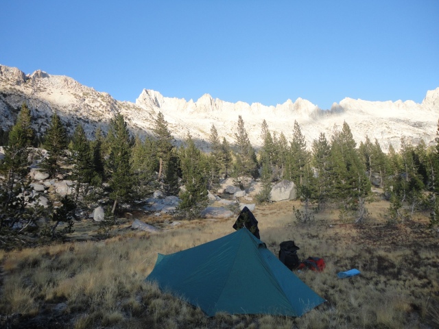
View of the Sawtooth Range from my campsite. Earlier this year the outdoor writer for the WSJ fell to his death while doing a traverse of the length of this range. Hiking by myself, I was sure to stay on the trail. Another solo hiker had died only a half mile off the trail at Slide Mountain near Mule Pass. His body was found 5 years later.
Day 5
The water bottle left outside the tent was partially frozen this morning.
A quarter mile up the trail I was surprised to meet a couple breaking camp. She had thru-hiked the PCT. The couple had gone cross-country from Virginia Canyon to Matterhorn Valley. They were headed to Mono Village.

In the cold morning I warmed by climbing to Burro Pass. There was plenty of water with a stream running down the length of this alpine meadow. I believe those mountains are the Three Sisters? Brothers? Oh well, the three something.

Warmed up, I stopped to shed some layers and dry my tarp.

At the top of Burro Pass looking down the other side toward Matterhorn Peak and the Matterhorn Valley.

View from upper Matterhorn valley back to Burro Pass with the Sawtooth Range just beyond.
Finally reaching end of seemingly endless meadows along Matterhorn Trail, I sat down for lunch at intersection with PCT. As I prepared granola peanut butter and honey on cinnamon and raisin muffins, a deer walked up and made its way around me.
Plenty of good water all of the way down Matterhorn Valley, a running stream and several springs.
The PCT south started a long climb out of Matterhorn Valley leading to a lake. I counted on the lake for water resupply.
At top I didn’t see a lake and since the map showed the trail only briefly touching lake, I wanted to make sure I didn’t miss it. I got out my map and GPS IPhone. No satellite signal so I threw down the map and climbed a rock. Seeing that lake was ahead, I went on about 0.2 mi to lake. As I was relaxing by the lake I decided to study the map. I discovered that my map was missing. Leaving my pack, I backtracked at a jog to recover the map. I was a little worried that a bear would make off with my pack during my short absence and that I would be stranded in the north country without gear.
At Virginia Canyon, I set up camp along the stream where there was the last water for miles. Soon a ranger came up on horseback. He told me that more rangers were behind him. They were doing some sort of cross country exercise. The ranger said nothing about my tent so I suppose I was set up far enough away from the stream.
Among the group of rangers that appeared next was one named Mark who has logged 10,000 miles in Yosemite over 20 years. He looked a little like Rambo and easily carried what appeared to be a very heavy pack.

Camp at lower end of Virginia Canyon
Day 6
I began a long hike through meadows along a long dry trail through Cold Canyon. It seemed like you could see the trail for miles ahead. About a mile before Glen Aulin I met a couple and spent a long while chatting. The lady was an ultra-marathoner and had done a 100 mile run along a famous route in California.

Cold Canyon

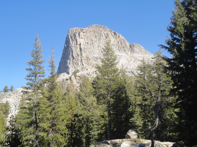
The more I looked at it, the more fascinated I became by this rock in Cold Canyon. With the long open approach, I had plenty of time to ponder the size and shape of this distant rock. These are some of the things that occupy the mind of the solo hiker.

Cold Canyon. I recognized that distant peak from my 2010 hike. It looks like a Chinese man’s hat. Those peaks are near Tuolomene Meadows.
At Glen Aulin I walked around the High Sierra Camp and ate lunch at the waterfall. There were a few other hikers present.

Glen Aulin
I moved on down the trail past several lakes and another creek with stranded fish. At the end of the day I passed the point where I had originally planned to turn past Toulomene Peak to make my way back to the Yosemite Falls trail. Instead, I went straight ahead joining the portion of the trail I had hiked in 2009. Climbing again I could look back with a view of Matterhorn Peak in the far distance. This was the same view I had in 2009 when I was first inspired to hike to Matterhorn.

View toward North

View South. Clouds Rest
I climbed up a large rock outcropping about a quarter mile. It was very exposed and I trembled a little at the feeling that I could fall off, but it really wasn’t bad. I sat on top and took in views of many points I had visited in Yosemite. The sun was quickly dropping and I descended and hiked on to a small lake where I set up camp among the trees and boulders.

Campsite
 Campsite

My dinner table for the night.
 The kitchen.

The moon was my companion each night as it gradually became full.
Day 7
Solitary quests give appreciation for comfortable existence.
Morning at unnamed lake trailside near Mt Hoffman-
Relaxing here after coffee and dark chocolate while laying on my pad spread on boulder with my back against a tree. I watch the birds flit around and move in as groups as they work their way across granite boulder and pine branch. The small wandering of birds sips tiny peeps while another solitary bird perched atop a pine calls with loud caw. Like every morning the sky is perfectly blue. Warmth is given to each rock as the morning sun spreads.

That morning during breakfast, I pondered this rock.
Thoughts – advantages of blue foam over thermarest.
I hiked on past Mays Lake where I began seeing people who had walked up from the parking lot.

I have returned to May Lake 3 years later.

Cool campsite with a view of Cathedral Peak. This spot is hidden over rock wall formation from trail and May Lake. I suppose people at May Lake High Sierra Camp come here for a night of ghost stories and marshmallows.

In distant background you can see rock formation that I climbed the night before. It was scary.
On across Tioga Road I met a man who talked about the views into the valley from Mt. Watkins. He was looking for a cross-country shortcut to Mt Watkins. I read a sign about the glacier that had deposited the sand and bolders that I was walking through.

This boulder was left by a glacier. I remember this boulder from 2009.
All of the day’s hike was a redo of 2009, only in the opposite direction. I descended steeply and thought about how I had forgotten about this climb in 2009. It must have been challenging. Reaching Snow Creek early I sat to kill some time. I didn’t want to be in camp too early so I rolled out my blue foam and began munching snacks. I took off boots and socks to let my feet air out. I now had a signal so I started sending some text messages. All of the sudden a bear and cub walked by, crossing the trail right in front of me. They had no idea that I was there. When they finally looked over they both took off. The mother bear crossed the trail and disappeared into the woods. The cub clung to the bottom of a tree only 20 feet away from me. It wouldn’t go away. I didn’t know whether to take time to put on my socks and boots and gather my things before scrambling out of there or to just run up the trail barefooted with whatever I could manage to grasp. I just sat there for a while trying to make a decision. Finally, the cub began to make distress noises. This motivated me. Expecting the mother bear to return I jumped up to leave the area in bare feet. Just as I moved the cub finally jumped off the tree and took off into the woods. I gathered up my things and hiked onto camp at Snow Creek falls.
That night I sat out on watching the clouds and storms gather over Half Dome. The sky cleared some and the sunset played out on valley. I visited the campfire of other campers and tasted their Jim Bean and roasted marshmallows (with graham cracker and chocolate bar). They had hiked down from Tioga Road. The couple lived in Guam where the man was a pilot for a major airline.

I camped nearby under some tree cover. Storms and wind appeared to be on the way so I chose to avoid camping in this beautiful open area. That night I watched the sunset from this area on the south side of Snow Creek Falls.

