13 Aug Hauling Trail Magic into Sierra Snow
This is part 2 of my June 2019 section hike in the Sierra.
Original Hike Plan Falls Victim to Injury
My intention had been to hike the PCT straight through from Lone Pine (Cottonwood Pass) to Mammoth Lakes (Reds Meadow); however, on the 2nd day out, I post-holed my right leg on a steep snow-covered slope, spraining my knee. I could still walk, but not with the confidence needed to push through all 7 of the major high mountain passes in these conditions.
My knee sprain occurred on June 15th and I hiked out at Kearsage Pass on June 18th. My flight out of Reno wasn’t until June 26th so having 8 days remaining, I decided to overnight at a Hostel California in Bishop, then hike out of Mammoth Lakes the next day. The new plan was to hike south on the PCT for several days, turning around at any point of my choosing before hiking back to Mammoth Lakes. If my knee began to act up, I could slow my pace and choose an earlier turnaround point.
Record Snow Year
This was a year of record snow accumulation and though now mid-June, many feet of snow remained. Mammoth Mountain had recorded 24 feet of snow in February. Residents there had to tunnel out of their homes. For the season, the summit of Mammoth Mountain had received 715 inches of snow. With 28 inches of snow recorded in May, the snow never eased up even in the late spring. Now, I was hiking only a few short weeks following the last of this record snowfall.

An Inspiration to Carry Trail Magic Deep into The Sierra
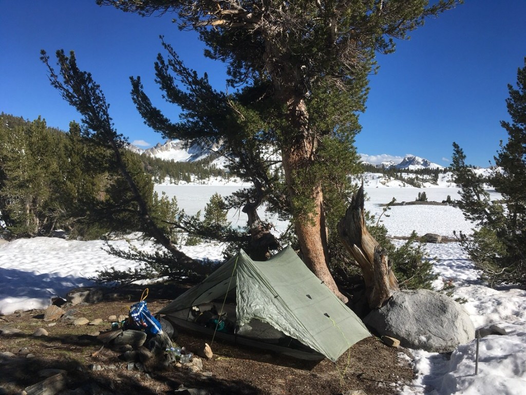
Stocking up on provisions at Vonn’s Grocery, I had a sudden inspiration to pack out with Trail Magic. Having no firm plan on how much distance to cover, I had no big worry about the weight I carried. I loaded up with a 6-pack of Sierra Nevada IPA and a 24 pack of assorted snack chips. I split the 6-pack, dropping the beer cans where they would fit deep in my pack. I tied the gigantic pack of chips to the outside of my pack. Carefully, lifting the weighty pack to my shoulders, I checked to see that I could manage the load. With a 6-pack of beer and 7 days of food, all of my care in packing ultra-light thus sacrificing luxury was now pretty much thrown out the window. One luxury that I had sacrificed was a camp stove. Everything meal I would eat would be cold-soaked. I was accustomed to cold-soaked oatmeal for breakfast, but cold-soaked meals for dinner would be new territory for me.
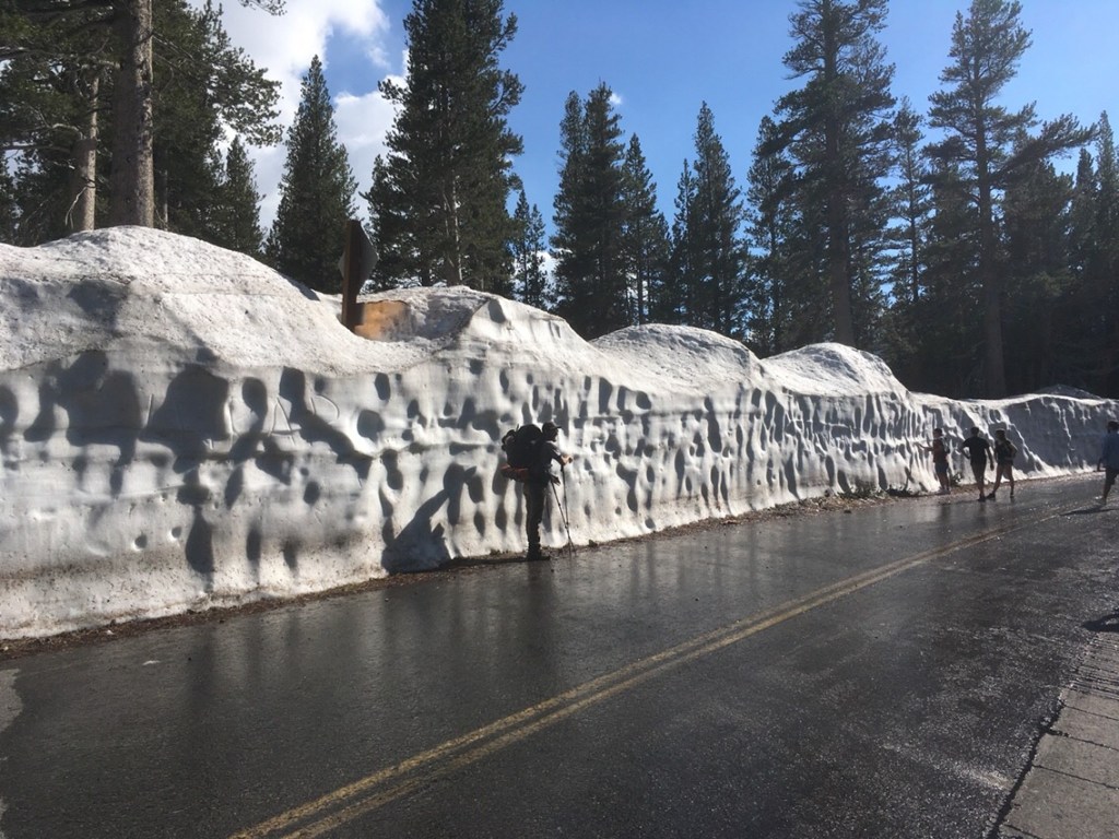
Snowed-In Roads and Getting to Horseshoe Lake
I had planned to take the shuttle from Mammoth Lakes to the crossing of the PCT near Reds Meadow. With the road still buried in snow, this shuttle wasn’t operating. Here I was in a strange town, miles away from the PCT desperately trying to figure out an alternate plan. Studying, bus routes, trails, and maps on Guthook and Google, I finally figured out the way to a trail that leads over Mammoth Pass to the PCT. I rode the town bus as far as possible. Next, I road walked, eventually hitching a ride for a couple of miles, then road walking more. I soon reached closed roads that were covered with tall mounds of snow. Finally, I reached the trailhead for the Mammoth Pass trail at Horseshoe Lake.


From Horseshoe Lake, I began GPS track-finding through the woods along snow-covered trail. Though thru-hikers had passed this way for R&R and resupply in Mammoth Lakes, the few tracks left on the firm ice soon disappeared in the afternoon sun. Fortunately, the PCT Guthook App included the GPS track for this PCT access-trail over Mammoth Pass.

Ice-Axe and Microspikes Required
After passing over Purple Lake Outlet, the trail ascended along switchback through the woods. Tracks leading down the creek bank indicated that many hikers had taken an off-trail route that descended in the opposite direction. Not feeling good about going off-trail, I chose to more closely follow the trail by cutting switchbacks while ascending steeply up the snow-covered slope. Near the top, I popped out of the woods. Ahead was a steep open traverse that crossed just above a near-vertical drop to large trees and boulders. I pulled out my ice-ax. With each step, I took a deep breath and I anchored my ice-ax as much as the brick-like frozen snow allowed. Feeling for the traction of my microspikes, I gazed below, imagining my fate should I slip and fall. Would I be able to self-arrest before skidding over the open drop or would I only pick up speed before slamming into the thick trees below? After a hundred feet of meticulous care, I was safe across the danger zone. Breathing a sigh of relief, I willed my heart rate to settle and I looked back to view my work. Although I had clearly been very near where the actual trail must lay beneath the ice, the hard snow showed very little of my prints. Likewise, there were no prints hinting that other hikers had come this way. This was a quite short, yet dangerous section. It had neither been mentioned by hikers, nor by trail guides or blogs. It is the big passes that get much attention and inspire dire warnings; however, given heavy snow conditions, many other short dangerous crossings deserve mention as well. Perhaps in a normal snow year, this short span would be completely unremarkable.
Several days later on my return trip, I sought to find a better way to cross this piece. Spying some exposed boulders I dropped lower. My idea was to rock scramble and use handholds on trees. Unfortunately, I found this lower route much too steep. I stepped off a boulder onto the ice and my microspikes began to slide. With a great deal of effort, I scrambled back up vertical boulders. After pulling myself up on top of a ledge, I puzzled around before choosing a crossing just below the route I took days earlier. There was no sign remaining in the snow of neither my crossing a few days before nor of any other hiker’s crossing.