
21 Jul Hiking the Sierra Snow
Hard Hiking – June 14th
After 2 days and 2 nights of traveling by plane, shuttle, train, and bus from Georgia to Lone Pine, I finally found myself standing on the side of Horseshoe Meadows road just outside. With no cars, I was desperately trying to hitch a ride to the top. After a half-hour of staring at the empty pavement, a jeep followed by a car appeared in the distance. Both vehicles slowed and pulled over. I hopped into the car. My ride was a guy from LA on his way to Horseshoe Meadows for a long weekend of backpacking. He had left Los Angeles about 3 AM that morning.
Here are my pack and my shadow as I hitchhike on deserted Horseshoe Meadows Road.

From Lone Pine, I carried a double meat foot long subway sandwich stuffed into the outside webbing of my new Waymark backpack. Soon after leaving Horseshoe Meadows, I was walking across patches of snow as I climbed toward Cottonwood Pass. Having come from near sea level, I was surprised to find myself mostly unaffected by the thin air of the 10,000-foot elevation. A short while after encountering the first snow patches, I navigated by GPS across large expanses of trail that lay hidden under snow. Nearing the top, I had to pause while I puzzled out a route to scramble up and around a steep snow slope just before the Cottonwood Pass trail intersected the PCT.
Here is a view of Horseshoe Meadows as I neared Cottonwood Pass.

Having barely reached the PCT, I encountered a PCT thru-hiker who was returning 30 miles to Cottonwood Pass and Horseshoe Meadows after having given up on his northbound journey. He reported that the snow had been too much. He had been dealing with either a knee or foot injury. His report wasn’t very inspiring. What had I taken on? Maybe I was crazy to want to hike the Sierra in June in a record snow year.
This was the last person I saw until eleven miles further when I reached my camp at Rock Creek. I spent most of the rest of the day walking snow and route finding using Guthook. At the end of the day, I reached 2-3 miles of mostly snow-free trail. What a difference a snow-free trail made! It felt like the brakes had been taken off. I accomplished my goal of hiking 14 miles to Rock Creek on the first day. It had been a little scary to be all alone while traversing miles of deep snow and navigating by GPS. Much of the time, I wondered how wise I could be considering that a young PCT thru-hiker had just hiked 30 miles to get out of what I was headed into. It had been hard, but I felt good. Fourteen more miles tomorrow. I can do this.
As you can see in photo below, I quickly realized that there would be a great deal of walking through the snow.

My first campsite was at Rock Creek.
Everything Changes – June 15th
My first day with an early start. Another 14 miles are planned and today I am starting 4 hours earlier., so I am as confident as I can be. With the record snowmelt, I worry about the creek crossings and Rock Creek is a dangerous looking swollen creek. As luck would have it, I have already dodged this bullet. The evening before, other nearby campers had given me directions to double log spanning the creek.
Rock Creek with log crossing.

After crossing, I spot an older man breaking camp. His name is Yoshida. He is a thru-hiker from Japan. Later that morning I pass a solo thru-hiker named Buddy. He takes a cigarette break and we talk. He asks whether I saw an older Japanese man. Buddy tells me that he and Yoshida have hiked together some, but that Yoshida hikes very slowly. He’s a little worried about Yoshida being on his own in these conditions. Buddy is also on his own. He says that he just doesn’t fit in well with the large groups of thru-hikers that are teamed up as “Trail Families”. I’m just glad to have finally seen several other people.

Shortly after a careful descent of a steep snow-covered slope, I reach the turnoff for Crabtree Meadows and Mt. Whitney. As usual, there are switchbacks hidden deep under the snow, but the only option is to follow tracks leading straight down. Upon wading across the Whitney creek with no problem, I met yet another thru-hiker that had turned around. This young man had fallen into Wright creek while crossing. He was soaked and became hypothermic. It wasn’t worth it and it was all he could take. He was backtracking the 25 miles to an exit at Cottonwood Pass.
Moving on, I approached Wallace Creek and began another descent straight down a steep snow-covered slope. My right leg post-holed, sinking its full length and anchoring firmly in the slope as the weight of my upper body leaned hard down the steep slope. With the sudden jerk, I felt a pop in my in the right knee of my anchored leg. This was followed by sharp knee pain. After extracting my leg, I tested the knee and found that I could still walk. It was a severe knee sprain so I would need to take care to avoid further strains. Continuing to walk, the pain soon diminished, however; my confidence also diminished. Here I was hiking all alone in extreme conditions that required pushing through miles of deep snow and across dangerous slopes. Ahead lay dangerous high mountain passes and swollen creek crossings, any of which could force me to turn back. On top of everything, I had a sprained knee that while okay, for the time being, was likely to be stiff and swollen the next morning.
Here is the slope where I felt a popping in my knee upon post-holing.

Wallace creek was swift but sufficiently spread out at the trail crossing to make it manageable. The icy water felt good on my knee. Rock Creek and Wallace Creek now having been vanquished, a little of my confidence crept back.
Here is Wallace Creek. This creek was a nearly a rock hop when I crossed at this spot last August.

Now, it was a short mile to the notorious Wright Creek where numbers of hikers had been swept away in 2017. Noon was approaching and the heat of the day was melting snow and causing the creek to rise. Wright Creek was not safe to cross at the trail. The trick was to hike a mile upstream where the creek passed through the gentler slopes of a meadow. For a mile below the meadow, Wright creek spilled steeply and forcefully through a gorge. At the meadow, I chose a course at a 45-degree angle downstream. As I reached the strongest current, the water rose above my waist and I felt my feet lose traction with the stream bed. At that moment I was lifted and carried toward a large rock. Just then, my feet landed upon a submerged rock. Grasping the large rock, I pulled myself out. This would turn out to be the hardest of many stream crossings of this trip.
Here is Wright Creek where it was too dangerous to attempt a crossing.

No longer needing to hurry to cross streams ahead of snowmelt, I took a long break on the northern bank of Wright Creek while eating cold-soaked chicken stew for lunch.
Here is my lunch spot. In the distance, you can see where I crossed Wright Creek.

The afternoon was an exhausting hike up and over snow-covered Big Horn Plateau followed by miles of wooded areas with high mounds of snow.
Here is Big Horn Plateau.

Mostly the hiking was by GPS. Finally, I reached the planned destination at Tyndall Creek. Here was no question about anyone crossing Tyndall Creek. There was no bridge. This creek was far worse than any I had seen. Guthook reported snow bridges, but I didn’t see any and couldn’t imagine how a snow bridge could last on this raging water. Following tracks, I hiked upstream beyond the trail crossing. At the top of the hill, the tracks turned around and so did I. Snow was everywhere. I wanted to cross but saw that it was impossible for anyone to cross. Hiking back down to the trail (somewhere under snow), I managed to find a small rocky patch that was free of snow. I pitched my tent; Hurt knee; Uncrossable stream; Hard day on the snow. I began thinking about a 28-mile hike back to the trailhead where I had started 2 days ago. Shortly, a group of 3 hikers came marching by. They had summited Whitney that very day and were at Tyndall Creek looking for a crossing to set up a summit of Forester Pass early the next morning. They followed the creek upstream and disappeared over the hill from which I had just returned. Soon other hikers dribbled by. They were all part of the same Tramily that had become spread out. With at least a dozen hikers passing, each, in turn, disappeared over the hill and none returned. Maybe they found a safe crossing where I didn’t. I resolved to hike further upstream in the morning. My hike was busted. I decided to exit at Kearsage Pass if I could only manage a Tyndall Creek crossing in the morning. Otherwise, I would be forced to backtrack 28 miles. Either way, I could not face over 100 miles of snow through the six high passes that lay beyond Kearsage. It was the snow more than anything. It was the uncertainty of knowing whether I could push through every pass and every creek crossing. It was doing it all alone. It was facing the snow, the creeks, and the navigation without the fortifying presence of others. It was my sprained knee. Could my knee hold out? Most of all it was the snow. The damned endless snow.
Forester Pass – June 16th
Having decided that I would either backtrack 28 miles for an exit at Horseshoe Meadows or hike on to an exit of Kearsage Pass, the stress of 100 plus miles of high passes and swollen streams is lifted. With the new plan, I have many extra days to fill, so I sleep late. I hate the idea of backtracking, so I’m resolved to explore further up Tyndal Creek. After all, I saw about 15 hikers go that way last night and they never returned. Maybe they found a way over the creek. Topping the hill and continuing upstream I began to see some areas where the creek spread out and slowed. High snowbanks on both sides were obstacles, but the creek was beginning to look more crossable. Hiking further, I heard some screaming and turned to see two girls down below and in the distance jumping up and down and waving their arms. When I turned toward them they pointed upstream and yelled to go further. I heard them yell, “Snow-bridge”. Hiking further, the stream spread more and soon I came to an enormous snow bridge that could easily be walked across. The two girls were Stark and Mayo. We began hiking across the open snow toward Forester Pass. I was glad to have someone to cross Forester with. Stark quickly fell behind and before long I saw that both had slowed down a great deal. Even after a very long break, the pair were not catching up. Once again on my own, I was a little disappointed but decided to move on to The Forester ascent.
Here are Stark and Mayo in the distance following very slowly. You can also see Tyndall Creek in the background.

At the top of Forester Pass. I had a minor close call when I fell at the top after crossing the chute. A snow step gave way while I was rock scrambling around the cornice at the top. I wound up hanging upside down clinging to a boulder. After a few moments to allow my heart rate to settle down. I carefully righted myself and worked my way back down over the rocks to the trail below. I then moved a little further down the trail where I rock scrambled a longer route above the Pass and back down to the other side. Stark and Mayo who were camped at the bottom of Forester later told me that watching my entire climb and seeing my fall at the top, nearly had heart failure. It must have looked worse than it was. Stark and Mayo decided to cross the next morning when the snow would be firmer. I was the last hiker that day to cross NOBO.
Below: Finally reaching snow-free switchbacks near the top of Forester Pass, I turn around to take a photo of the view looking south.


Here is where I attempted to walk off a ridge on the northern side of Forester Pass. It was too steep to walk down and I post holed and tweaked my knee again. At that point, I chose to glissade the rest of the way down.

Here is another of my glissade tracks. Before glissading, I discovered that I had lost my ice-ax and had to hike back up for over a quarter-mile before finding the ice-ax.

I found my ice-ax!


Bullfrog Lake Trail – June 17th
I had camped early next to a creek that flows into Bubbs Creek. A good log for the crossing had been a little wet that afternoon. The next morning it was covered in ice, so I searched for another way to cross this fast-moving creek. I found a very steep snowbank that extended over most of the creek leaving only a 2-foot gap between the bank and a boulder on the opposite bank. I attempted to ease my way down the steep snowbank and onto the boulder. I immediately slid out of control toward the rushing water. I aimed my legs toward the rock on the opposite bank awkwardly landing both feet on the opposite bank and tottered over the rushing water as I fought to regain balance. I pushed to a standing position on the boulder and smiled to myself as I considered the insane way that I had crossed this creek.
My strategy today was to extend what would normally be a one day hike to two days. I took frequent breaks while filming creeks and waterfalls. Later in the day, I began to run into numbers of other hikers, most of whom were headed out Kearsage Pass for resupply. I managed to find a hidden small snow-free spot above the Bullfrog Lake trail where I set up an early camp.
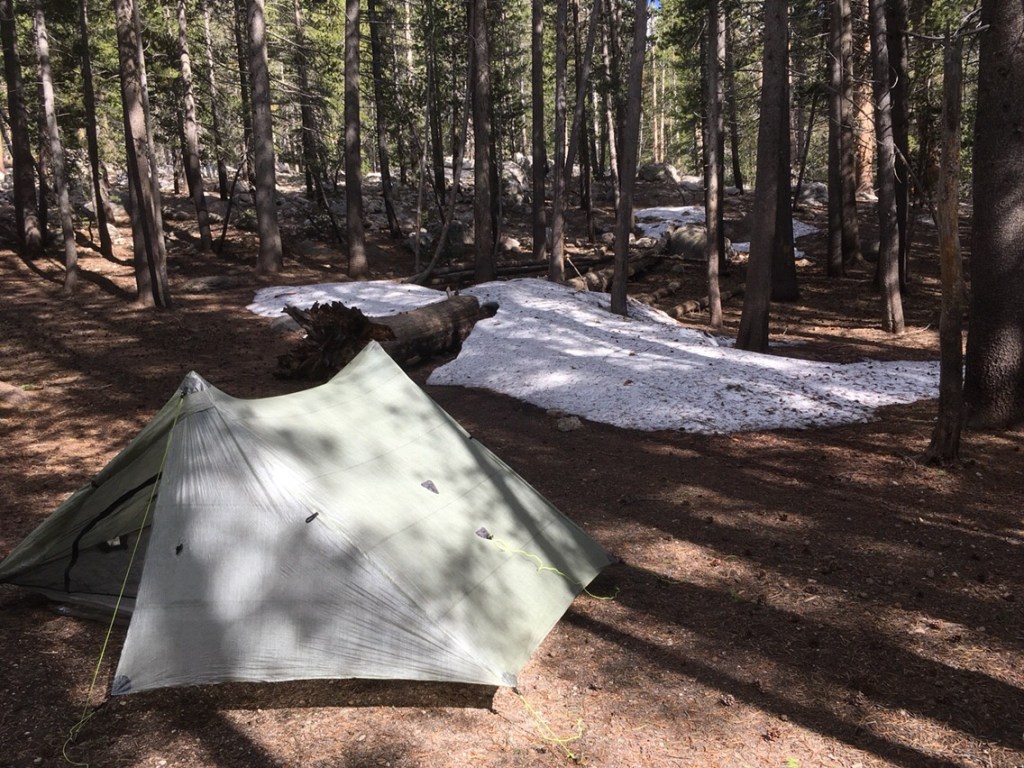
Here is my tent near Bubbs Creek.

Kearsage Pass – June 18th
I ran into Stark and Mayo again shortly before reaching Kearsage Pass. We had some fun doing several short glissades on the descent toward Onion Valley.
Here are photos of my tent site above the trail leading toward Bullfrog Lake and Kearsage Pass.

You can see that there is only a tiny snow-free dry patch of ground. This spot was made possible by the sun-facing slope in combination with the sheltering branches of a large tree. With few exceptions, the entire area around this trail was covered with snow. The rare bare spots were not level.

Here is the view of a lake from the same tent site.

Here is a view of the trail looking west toward Bullfrog Lake and the PCT.

This shows yet another danger of hiking the PCT. A boulder that has rolled down the slope and over the trail. Other hikers spoke of narrowly escaping a sparking mini-van sized boulder as they ascended the icy slopes of Mount Whitney by the full moon.

I hitched a ride to Independence where I ate lunch at a Taco food truck. The 395 bus wasn’t due for a few more hours so I hitched again to Bishop where I stayed at Hostel California. I was surprised to find that “The Graduate” was running the hostel. I had met The Graduate and his wife, T-Rex, last year near Ashland while hiking the PCT. They were working on a Calendar Year Triple Crown that they later completed that December. It was great talking to The Graduate.